The island of Virgen Maria was so hidden by mist that they could never get a sight of it. They saw the other island of Belen*, and passed near another, 7 leagues long. It consisted of a very high hill, almost like the first. It received the name of Pilar de Zaragoza. It is the Ureparapara of modern charts. Many growing crops, palms, and other trees, and columns of smoke were seen on it. It was about 30 leagues to the N.W. of the bay; but there were no soundings and no port.
[* Vanua Lava, in the Banks group.]
They diligently sought its shelter, but were obliged to give it up owing to the wind and current; and on the next day they found themselves at sea, out of sight of land.
Queiroz made an attempt to reach Santa Cruz where, in case of separation, the fleet was to rendezvous in Graciosa Bay. He failed to reach that island and sailed for Acapulco, which he sighted on the 3rd of October, 1606, and thence overland he reached Mexico with a small escort on his way back to Spain, where he arrived destitute.
On his return to Spain, Queiroz reported to the king the discovery of the Australian continent. Thus it came to pass, in after years, that Australia was represented as shown in the accompanying map, and not until the French navigator Bougainville, and after him our immortal Cook, re-discovered the New Hebrides, was the illusion concerning Queiroz’s discovery of Australia thoroughly dispelled.
In a work published in Paris, in 1756, the same year, therefore, as the map by Vaugondy, given here, De Brosses, the author of a work on Australian Discovery, describing New Holland, the name then given to Australia, says:—
“On the eastern coast is the Terre du St. Esprit (the Land of the Holy Ghost), discovered by Queiroz.”
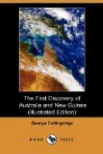
SPANISH MAP OF THE BAY OF ST. PHILIP AND ST. JAMES IN ESPIRITU SANTO ISLAND (NEW HEBRIDES).
The map given here was drafted by Don Diego de Prado, the cartographer of Queiroz’ fleet. When compared with a modern map (see pp. 97-114), it will be seen how correct it is. The Spaniards approached their anchoring ground from the north and the perspective elevations of the hilly country is given as seen from the decks of their ships, a common practice in those days, but one, which in this case, necessitated placing the south on top; for purposes of comparison, it will be necessary, therefore, to reverse the map, mentally or otherwise.
The original map, which is of a much larger size, bears an inscription in Spanish (for want of space incomplete in my copy), referring to the discovery, date of taking possession, latitude, etc. It draws attention to the anchors marked in the bay and says that in those places the ships cast anchor. It will be noticed that no less than nine of these anchorages are marked, and that most of them are in the port of Vera Cruz. The inscription says also that the Capitana left them on the 11th of June.


