[Footnote 1: Tacitus, the Oxford Translation, revised 1854, vol. 1, book xii. pp. 288-90.]
[Footnote 2: Roy, Major Gen. William: “The Military Antiquities of the Romans in Britain,” 1793, Plate xi.]
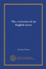
[Illustration: A Sketch Map of the Roman Road from Malton to the Coast, and a Plan of the Camps on the Road at Cawthorne. (From the Ordnance Survey.)]
Coming to the firmer ground of the actual remains of the Roman roads and camps, we find that traces of a well-constructed road, locally known as Wade’s Causeway, have been discovered at various points on a line drawn from Malton to Cawthorne and Whitby. Some of these sections of the road have disappeared since Francis Drake described them in 1736,[2] and at the present time the work of destruction continues at intervals when a farmer, converting a few more acres of heather into potatoes, has the ill-luck to strike the roadway.
[Footnote 2: Drake, Francis: “Eboracum,” p. 36.]
In the month of January this year (1905), I examined a piece of ground newly taken under cultivation at Stape. It was about half a mile north of the little inn and just to the west of Mauley Cross. The stones were all thrown out of their original positions and a pile of them had been taken outside the turf wall for road-mending and to finish the walls against the gate posts, but the broad track of the roadway, composed of large odd-shaped stones, averaging about a foot in width, was still strikingly in evidence—a mottled band passing straight through the chocolate-coloured soil.
All who have described the road state that on each side of the causeway where it remains undisturbed there is a line of stones placed on their edges in order to keep the stones in place, but in this instance the stones were too much disturbed to observe their original formation. Among the furrows I discovered quantities of flint-flakes, indicating the manufacture of stone implements on this site, no flints being naturally found in the neighbourhood.
The road went through the most perfectly constructed of the three square camps at Cawthorne from west to east, cutting through one corner of the adjacent oval camp. It then seems to have passed down the slack a little to the north-east, and crossing the stream below (probably in Roman times by a wooden bridge) it takes a fairly straight course for the little hamlet of Stape just mentioned. The slope from the camps is extremely steep, and in 1817, when Dr Young wrote his “History of Whitby,” he tells us that there were no traces of the road at that point. Going back to 1736, however, we find that Drake, in his “History of York” published in that year, says, “At the foot of the hill began the road or causeway, very plain”; he also tells us that he first heard of the road, with the camp upon it, from Mr Thomas Robinson of Pickering—“a gentleman well versed in this kind of learning.” Drake, enthusiastically describing his examination


