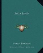
As an illustration of the difficulty of identifying places in ancient Peru, it is worth noting that the gateway now called Rumiccolca is figured in Squier’s “Peru” as “Piquillacta.” On the other hand, the ruins of the large city, “covering thickly an area nearly a square mile,” are called by Squier “the great Inca town of Muyna,” a name also applied to the little lake which lies in the bottom of the Lucre Basin. As Squier came along the road from Racche he saw Mt. Piquillacta first, then the gateway, then Lake Muyna, then the ruins of the city. In each case the name of the most conspicuous, harmless, natural phenomenon seems to have been applied to ruins by those of whom he inquired. My own experience was different.
------
Figure
Lucre Basin, Lake Muyna, and the City Wall of Piquillacta
------
Dr. Aguilar, a distinguished professor in the University of Cuzco, who has a country place in the neighborhood and is very familiar with this region, brought me to this ancient city from the other direction. From him I learned that the city ruins are called Piquillacta, the name which is also applied to the mountain which lies to the eastward of the ruins and rises 1200 feet above them. Dr. Aguilar lives near Oropesa. As one comes from Oropesa, Mt. Piquillacta is a conspicuous point and is directly in line with the city ruins. Consequently, it would be natural for people viewing it from this direction to give to the ruins the name of the mountain rather than that of the lake. Yet the mountain may be named for the ruins. Piqui means “flea”; llacta means “town, city, country, district, or territory.” Was this “The Territory of the Fleas” or was it “Flea Town”? And what was its name in the days of the Incas? Was the old name abandoned because it was considered unlucky?
Whatever the reason, it is a most extraordinary fact that we have here the evidences of a very large town, possibly pre-Inca, long since abandoned. There are scores of houses and numerous compounds laid out in regular fashion, the streets crossing each other at right angles, the whole covering an area considerably larger than the important town of Ollantaytambo. Not a soul lives here. It is true that across the Vilcanota to the east is a difficult, mountainous country culminating in Mt. Ausangate, the highest peak in the department. Yet Piquillacta is in the midst of a populous region. To the north lies the thickly settled valley of Pisac and Yucay; to the south, the important Vilcanota Valley with dozens of villages; to the west the densely populated valley of the Huatanay and Cuzco itself, the largest city in the highlands of Peru. Thousands of people live within a radius of twenty miles of Piquillacta, and the population is on the increase. It is perfectly easy of access and is less than a mile east of the railroad. Yet it is “abandonado—desierto—despoblado”! Undoubtedly here was once a large city of great importance. The reason for its being abandoned appears to be the absence of running water. Although Mt. Piquillacta is a large mass, nearly five miles long and two miles wide, rising to a point of 2000 feet above the Huatanay and Vilcanota rivers, it has no streams, brooks, or springs. It is an isolated, extinct volcano surrounded by igneous rocks, lavas, andesites, and basalts.


