The routes proposed by the Rapid Transit Board in 1895, after municipal ownership had been approved by the voters at the fall election of 1894, contemplated the occupation of Broadway below 34th Street to the Battery, and extended only to 185th Street on the west side and 146th Street on the east side of the city. As has been told in the introductory chapter, this plan was rejected by the Supreme Court because of the probable cost of going under Broadway. It was also intimated by the Court, in rejecting the routes, that the road should extend further north.
It had been clear from the beginning that no routes could be laid out to which abutting property owners would consent, and that the consent of the Court as an alternative would be necessary to any routes chosen. To conform as nearly as possible to the views of the Court, the Commission proposed, in 1897, the so called “Elm Street route,” the plan finally adopted, which reached from the territory near the General Post-office, the City Hall, and Brooklyn Bridge Terminal to Kingsbridge and the station of the New York & Putnam Railroad on the upper west side, and to Bronx Park on the upper east side of the city, touching the Grand Central Depot at 42d Street.
Subsequently, by the adoption of the Brooklyn Extension, the line was extended down Broadway to the southern extremity of Manhattan Island, thence under the East River to Brooklyn.
The routes in detail are as follows:
[Sidenote: Manhattan-Bronx Route]
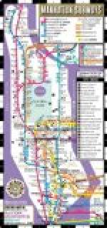
Beginning near the intersection of Broadway and Park Row, one of the routes of the railroad extends under Park Row, Center Street, New Elm Street, Elm Street, Lafayette Place, Fourth Avenue (beginning at Astor Place), Park Avenue, 42d Street, and Broadway to 125th Street, where it passes over Broadway by viaduct to 133d Street, thence under Broadway again to and under Eleventh Avenue to Fort George, where it comes to the surface again at Dyckman Street and continues by viaduct over Naegle Avenue, Amsterdam Avenue, and Broadway to Bailey Avenue, at the Kingsbridge station of the New York & Putnam Railroad, crossing the Harlem Ship Canal on a double-deck drawbridge. The length of this route is 13.50 miles, of which about 2 miles are on viaduct.
Another route begins at Broadway near 103d Street and extends under 104th Street and the upper part of Central Park to and under Lenox Avenue to 142d Street, thence curving to the east to and under the Harlem River at about 145th Street, thence from the river to and under East 149th Street to a point near Third Avenue, thence by viaduct beginning at Brook Avenue over Westchester Avenue, the Southern Boulevard and the Boston Road to Bronx Park. The length of this route is about 6.97 miles, of which about 3 miles are on viaduct.
[Illustration: MAP SHOWING THE LINES OF THE INTERBOROUGH RAPID TRANSIT CO. 1904]
At the City Hall there is a loop under the Park. From 142d Street there is a spur north under Lenox Avenue to 148th Street. There is a spur at Westchester and Third Avenues connecting by viaduct the Manhattan Elevated Railway Division of Interborough Rapid Transit Company with the viaduct of the subway at or near St. Ann’s Avenue.


