This supply is taken from the South Fork of Bonito Creek, which flows down the eastern slope of White Mountain. The latter is 12,000 ft. high, and is 16 miles south of Carrizozo (Fig. 1). The watershed is a granite and porphyry formation, heavily timbered, and the stream is fed by snow and rain. This combination yields an excellent water, carrying on an average 6.05 grains of incrusting and O.95 grains of non-incrusting solids per gallon. The North Fork of the creek carries 16.60 and 2.40 grains, respectively. Below the junction of these forks, the water contains 10.48 grains of incrusting and 1.57 grains of non-incrusting solids per gallon; and a branch pipe line takes water from the creek during intervals in dry years when the daily flow of the South Fork is less than the consumption.
The Water Plant.—The water is taken to and along the railway in pipe lines. The system includes 116 miles of wood pipe, 19 miles of iron pipe, one 422,000,000-gal. storage reservoir, four 2,500,000-gal. service reservoirs, two pumping plants in duplicate, and accessories of valves, stand-pipes, etc.
From a small concrete dam across the creek at an elevation of 7,728 ft., the pipe line drops down the narrow valley eastward, 5-1/2 miles, to an elevation of 6,980 ft, where it turns abruptly north, rising in 1 mile to a table-land, 7,215 ft. above sea level, across which it continues northward 5 miles to the storage reservoir, which is on the north edge of this elevated country. Hereafter, this reservoir will be called the Nogal Reservoir, from the old mining village of Nogal lying 1-1/2 miles to the north and 600 ft. below it. From this reservoir, the line drops abruptly to the Carrizozo plain, and crosses the latter northward to Coyote, at Mile 156, on the railway, at an elevation of 5,810 ft., passing, on the way, 6 miles east of Carrizozo, to which a branch pipe runs, Carrizozo being 5,430 ft. above sea level. There is a 2,500,000-gal. reservoir at Coyote, and a similar one at Carrizozo.
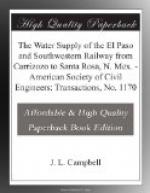
[Illustration: Fig 1. Map of lines of El Paso & Southwestern system]
This describes the gravity section of the line which brings the water from the mountain stream to the railway. From Nogal Reservoir to the latter, the capacity of the pipe is equal to the future daily requirements; from the source of supply to the reservoir, the pipe has twice as great a capacity, thereby storing surplus water. This section is 32 miles long, with a 6-mile branch line.
The second, or pumping section, extends eastward along the railway, rising from an elevation of 5,810 ft. at Coyote to 6,750 ft. on the Corona summit, which is the water-shed line between the Rio Grande on the west and the Rio Pecos on the east. At Coyote a pumping station lifts the water to Luna Reservoir and the pumps at Mile 171, and the latter lift it to the reservoir on Corona summit at Mile 192-1/2. This section is 36-1/2 miles long.


